Top 10 Golden Larch Hikes in Washington that are not Maple Pass
Last Updated on October 10, 2026
I know it’s a little sassy to leave Maple Pass off this list of larch hikes (it is an incredible hike after all), but you don’t need my help to find it! I’m not including a couple other popular ones like Colchuck Lake (in my opinion not a great larch hike compared to these others) and the Enchantments. You don’t need me to learn about those.
Let’s get beyond the most popular and busy spots for some new ideas, shall we?
(Yes, I did include some super busy ones too – crowd levels are noted for each hike)
For a few short weeks a year, as the summer comes to an end and fall rapidly approaches, a glorious lime green then bright gold then orange tree covers the high eastern slopes of the Cascade mountains. This is the time of year for larch hikes in Washington State!
A born and raised Washingtonian, I didn’t know about larches until college, when one of my good friends shared his love of them with me. Once I knew about them, I was hooked. Once you start larch hiking, it will fast become an annual tradition. This article is all about where the larches are in general, when is the best time to see them, what to pack for your larch hike, avoiding crowds and my favorite larch hikes in Washington.
It’s hard to limit the list to just the Top 10, but I think it’s helpful to have a shorter list since you can only see the larches in their golden splendor for about three weeks each fall. For each hike I’ll tell you WHY it makes the cut, as well as how difficult the hike is, crowd levels, how far it is from Seattle and perfect local places to stop after.
- What are Golden Larches?
- Where are Larches in Washington?
- When is the best time for Larch hikes in Washington?
- What to bring for larch hiking
- Top 10 Larch hikes in Washington State
What are Golden Larches?

Larches are an unusual tree as they are a deciduous conifer. Deciduous means that the tree grows new leaves each year in the spring and then sheds them in the fall. Larches have needles instead of leaves, but they work the same way. The larch tree grows new needles that are bright green in spring, and then in the fall they turn color just like many other trees that lose their leaves. The chlorophyll in the needles is drawn back into the tree which leaves the yellow color. Eventually, the needles fall off before winter, like other deciduous trees.
Where are Larches in Washington?
In Washington State, larches are generally found on the east slopes of the Cascade Crest north of Snoqualmie Pass and in Northeastern Washington above 3000 feet of elevation, going up to around 7000 feet of elevation.
They are also abundant throughout other parts of the Pacific Northwest and Mountain west, including British Columbia, Alberta, Idaho and Montana.
Prefer to Listen?
When is the best time for Larch hikes in Washington?
Larch season is late September through late October in Washington State. The peak of larches varies a bit from year to year, and it varies with elevation. The highest elevation larches turn before the lower elevation ones. Heavy wind or snow can bring an early end to larch season, while sunnier and drier weather can sometimes extend the season till late in October. In the North Cascades, early October is when you want to go, in Eastern Washington late October and other places somewhere in between.
The best way to determine the conditions for larch hikes in Washington is to utilize the Washington Trails Association trip reports. Other hikers will often note how close the larches are to their peak. To filter the results, you can put in the name of a specific hike or you can go to “advanced options” and enter larch into the search line. You can also filter by month.
In addition to telling you if the larches are at or near their peak, you can also determine how crowded a specific trail is and you can learn other important information such as if there is snow on the trail, which is common during larch season, especially at higher elevations.
If you’re looking to get beautiful larch photos, look for a sunny day when the larches show up dramatically against the blue sky. Early morning and late afternoon light can often make the larches look even more incredible!

If you’re a backpacker, backpacking in larch country can make for an incredible photography opportunity catching the larches at sunrise and sunset. Trails with backpacking opportunities are listed below.
What to bring for larch hiking

When heading out on one of these amazing larch hikes in Washington, it’s imperative to be prepared for winter conditions, including extra layers, extra food (consider bringing hot food, YUM) and a really good rainjacket.
Being extra prepared is important with rapidly changing weather, shorter days and very cold nights. Read more here about what I wear for a day hike throughout the year as well as what I bring on a day hike.
Top 10 Larch Hikes in Washington State
There are many other larch hikes in Washington, but these are the ones I recommend as the very BEST to maximize this short and glorious season. They’re listed in order of their driving time from Seattle.
Lake Ingalls and Headlight Basin – Teanaway (2 hours from Seattle)

- Why it’s one of the best larch hikes in Washington: Lake Ingalls is in my top 3 for sure, because of it’s relatively close proximity to Seattle, it’s beautiful larches, dramatic views of Mt Stuart and the spectacular lake at the end. The only downside to this hike is that it is extremely crowded on fall weekends. If possible, do this hike on a weekday (it’s worth a vacation day!) and if not get there extremely early. Spending the night camping in Headlight Basin is another good way to avoid crowds. While there are lots of backpackers here, there are plenty of spots and you get a break from the day trip crowds, along with stunning sunset, sunrise and golden hour photos.
- How to get there: From I-90 just east of Cle Elum, take Highway 970 towards Blewett Pass. Turn left on Teanaway Road about 9 miles from the freeway. Follow Teanaway Road until it dead ends at the trailhead in about 23 miles.
- Passes Needed: Northwest Forest Pass
- Crowd Level: Extreme, even on weekdays
- Best Time: Early October
- Dog Friendly: Partially – dogs are allowed on leash as far as Ingalls Pass, but not beyond into Headlight Basin or at Lake Ingalls.
- Length of Hike: 9 miles to Lake Ingalls round trip, 8 miles round trip to Headlight Basin, 7 miles round trip to the pass (where the larches start).
- Elevation Gain: 2500 feet
- Backpacking Options: Headlight Basin is a fantastic place to backpack among the larches and see amazing dark skies at night as well as gorgeous alpenglow at sunset on Mt Stuart and beautiful sunrises. Camping is not allowed at the lake. There are also several campgrounds along the Teanaway Road.
- Where to Stop after: Grab a beer in Roslyn or Cle Elum, coffee at Pioneer Coffee (also great breakfast options) or grab a bigger meal at the Roslyn Cafe. Dru Bru in Cle Elum has an excellent pizza food truck too.
Swauk Forest Discovery Trail – Blewett Pass (2 hours from Seattle)

- Why it’s one of the best larch hikes in Washington: This is a great place to stop and stretch your legs driving over Blewett Pass any time of year. When the golden larches are out, this becomes a truly magical loop through the forest with lots of interpretive signs. It also doesn’t require a long drive on a gravel road and it is never crowded. You can see larches right from the parking lot!
- How to get there: The trail head has a sign at Blewett Pass, turn at the sign at the summit and park. To get to Blewett pass, follow Highway 97 north from I-90 or south from Highway 2.
- Passes Needed: Northwest Forest Pass
- Crowd Level: Minimal
- Best Time: Late October
- Dog Friendly: yes, on leash
- Length of Hike: 2.5 mile loop
- Elevation Gain: 600 feet
- Backpacking Options: No, although several campgrounds are nearby and there are lots of opportunities for dispersed camping near Blewett Pass.
- Where to Stop after: If you’re heading back south, Grab a beer in Roslyn or Cle Elum, coffee at Pioneer Coffee (also great breakfast options) or grab a bigger meal at the Roslyn Cafe. If you’re heading north towards Wenatchee, try the Lemolo Cafe in downtown Wenatchee (delicious sandwiches, salads and calzones) or Wenatchee Valley Brewing.
Manastash Lake – Ellensburg (2.5 hours from Seattle)

- Why it’s one of the best larch hikes in Washington: There are no views and NO CROWDS on this beautiful trail to Lost Lake and Manastash Lake. You will be sharing the trail with dirt bikes and hunters in the fall. I don’t mind this and love an uncrowded trail with other trail users more than a crowded hiker only trail. But it’s good to keep in mind if you feel differently. You’ll find true solitude and beauty here in Central Washington.
- How to get there: To get there, take the Thorp exit from I-90 and go left on Thorp Way. In about two miles, turn right on Cove Road then right on Manastash Road just a bit over four miles further. Keep following Manastash Road, it turns to gravel and gets narrow and winding. This part is slow. When you’re almost to the trailhead there’s a fork in the road and a sign pointing left for Manastash Lake. After you go left, you’ll dead end in the parking lot in about half a mile.
- Passes Needed: Northwest Forest Pass
- Crowd Level: None, but prepare to share the trail with a few courteous dirt bike users
- Best Time: Late October
- Dog Friendly: Yes, on leash
- Length of Hike: 8 miles round trip to Manastash Lake
- Elevation Gain: 1100 feet
- Backpacking Options: Yes, there are several lovely campsites around both Lost Lake and Manastash Lake
- Where to Stop after: Dru Bru or Pioneer Coffee in Cle Elum are excellent post hike stops.
Lake Clara – Wenatchee area (3 hours from Seattle)

- Why it’s one of the best larch hikes in Washington: Lake Clara is a perfect destination if you want to see some larches on a shorter hike with less climbing than some of the others. It’s a lovely forest walk to a small lake surrounded by golden larches. This is a particularly good larch hike for kids.
- How to get there: The trail starts in the parking lot for Mission Ridge Ski Area near Wenatchee.
- Passes Needed: None
- Crowd Level: Minimal
- Best Time: Early to Mid October
- Dog Friendly: yes, on leash
- Length of Hike: 3.5 miles round trip
- Elevation Gain: 900 feet
- Backpacking Options: No
- Where to Stop after: Lemolo Cafe and Deli in Wenatchee is right downtown and has amazing sandwiches, coffee and more. If you’re looking for a classic brewpub, give Wenatchee Valley Brewing or Badger Mountain Brewing a try!
Carne Mountain – Leavenworth area (3+ hours from Seattle)
- Why it’s one of the best larch hikes in Washington: This is the best larch hike for those who really want a tough workout. It’s long and steep and also has spectacular larches and scenery. It’s also a long drive on a challenging road that is unpaved for the last 14 miles.
- How to get there: Turn towards Lake Wenatchee off Highway 2 between Leavenworth and Stevens Pass. 4 miles from Highway 2, head right on the Chiwawa Loop Road. Half a mile later turn right on County road 22. In just under a mile, turn left on Chiwawa River Road. In just over 10 miles the pavement ends and becomes more rough as you go. Turn right on Phelps Creek Road, about 11 miles after the pavement ends. In just over 2 more miles, arrive at the the trailhead.
- Passes Needed: Northwest Forest Pass
- Crowd Level: Moderate
- Best Time: Mid to late October
- Dog Friendly: yes, on leash
- Length of Hike: 7.5 miles round trip
- Elevation Gain: 3600 feet
- Backpacking Options: backpacking is allowed in this area of the Okanagan Wenatchee National Forest
- Where to Stop after: Head for Icicle Creek Brewing or the Munchen Haus in Leavenworth.
Cutthroat Lake and Cutthroat Pass – North Cascades (3.5 hours from Seattle)

- Why it’s one of the best larch hikes in Washington: A gorgeous and less crowded than Maple Pass (across the street) option along the well maintained Pacific Crest Trail. You have the option here to start on the Pacific Crest Trail and do a one way hike to Cutthroat Lake if you have two vehicles. I like to start at the Cutthroat Lake Trailhead side.
- How to get there: The Pacific Crest Trail north from Rainy Pass is just east of and almost across the road from Maple Pass. To do Cutthroat Lake only, the trailhead is a few miles east.
- Passes Needed: Northwest Forest Pass
- Crowd Level: Moderate – many fewer crowds than at the Pacific Crest Trail, but still busy and you’ll be parking up to a mile away. No crowds between Cutthroat Lake and Cutthroat Pass from this side.
- Best Time: Early October
- Dog Friendly: yes, on leash
- Length of Hike: 10 miles round trip to Cutthroat Pass and back, 11 miles one way from the Pacific Crest Trail to Cutthroat Lake, 4 miles round trip to the lake and back
- Elevation Gain: 2000 feet to Cutthroat Pass, 400 feet to Cutthroat Lake only
- Backpacking Options: You can camp in various places along the Pacific Crest Trail.
- Where to Stop after: In Winthrop, check out the Old Schoolhouse Brewery for beer and the Rocking Horse Bakery for coffee, soups and sandwiches! Looking for pizza? Check out East 20 Pizza. The Mazama Store is also an excellent stop.
Blue Lake – North Cascades (3.5 hours from Seattle)

- Why it’s one of the best larch hikes in Washington: One of the shorter and less steep larch hikes out there, Blue Lake includes an alpine lake and incredible mountains towering around it. It has great views in several places along the trail in addition to the lake area.
- How to get there: The Blue Lake Trailhead is four miles east of Rainy Pass on the North Cascades Highway, approximately 56 miles east of Marblemount and 31 miles west of Winthrop.
- Passes Needed: Northwest Forest Pass
- Crowd Level: Extreme, even on weekdays
- Best Time: Early October
- Dog Friendly: yes, on leash
- Length of Hike: 4.5 miles round trip
- Elevation Gain: 1000 feet
- Backpacking Options: No
- Where to Stop after: In Winthrop, check out the Old Schoolhouse Brewery for beer and the Rocking Horse Bakery for coffee, soups and sandwiches! Looking for pizza? Check out East 20 Pizza. The Mazama Store is also an excellent stop.
Goat Peak Lookout – North Cascades (4 hours from Seattle)
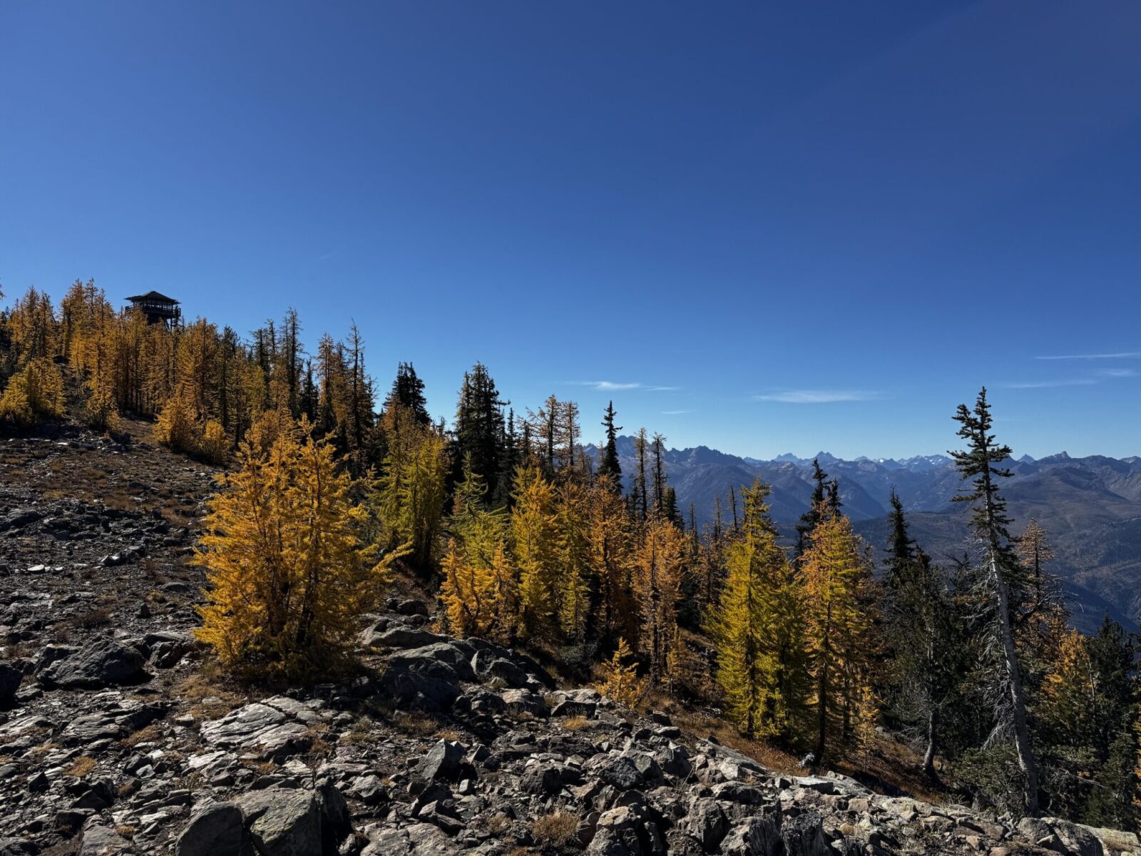
- Why it’s one of the best larch hikes in Washington: This stunner, Goat Peak Lookout, is short but steep – offering a commanding view in all directions and that feeling of walking along a magical larch covered trail. It is also much less crowded and easy to park at compared to most other North Cascades hikes along the North Cascades Highway – thanks to the 45 minute gravel road drive from Mazama.
- How to get there: From Mazama on Lost River Road, turn right on Goat Creek Road (at the stop sign by the trail center). Go just under two miles and turn left on Forest Service Road 52. Follow it almost three miles and then turn left on Forest Service Road 5225. In just over six miles, turn right on Forest Service Road 200 for three miles where it ends at the trailhead.
- Passes Needed: Northwest Forest Pass
- Crowd Level: Minimal
- Best Time: Early October
- Dog Friendly: Yes, on leash
- Length of Hike: 8.5 miles round trip
- Elevation Gain: 2300 feet
- Backpacking options: None
- Where to Stop after: In Winthrop, check out the Old Schoolhouse Brewery for beer and the Rocking Horse Bakery for coffee, soups and sandwiches! Looking for pizza? Check out East 20 Pizza. The Mazama Store is also an excellent stop.
Grasshopper Pass – North Cascades (4.5 hours from Seattle)

- Why it’s one of the best larch hikes in Washington: Grasshopper Pass is my personal absolute favorite larch hike in Washington! It’s very remote and the road to get there is long and challenging. Once you get there, this hike is never steep and every single step is spectacular. You could walk a mile on this section of the Pacific Crest Trail and it would still be amazing. There are larches upon larches, views upon views and it’s just amazing and no crowds.
- How to get there: Grasshopper Pass is in a remote area of the North Cascades. To get there, turn on Lost River Road in Mazama from the North Cascades Highway. Leaving Mazama on Lost River Road, expect the next 15 miles to the trailhead to take close to an hour. It’s a narrow road! After a bit of pavement past some houses and a campground (and several dispersed camping options), continue on the Lost River Road which later is just called Forest Road 50.
- Passes Needed: Northwest Forest Pass
- Crowd Level: Moderate – a lot of hikers are finishing the Pacific Crest Trail this time of year, which can make it a bit busier at campgrounds and trailheads that you might expect in such a remote location
- Best Time: Early October
- Dog Friendly: yes, on leash
- Length of Hike: Up to 9.5 miles
- Elevation Gain: Up to 1500 feet
- Backpacking Options: There are multiple options for places to camp along the Pacific Crest Trail.
- Where to Stop after: The Mazama Store as well as the Old Schoolhouse Brewery for beer and the Rocking Horse Bakery for coffee, soups and sandwiches! Looking for pizza? Check out East 20 Pizza
Sherman Peak Loop – Northeast Washington (6 hours from Seattle)
- Why it’s one of the best larch hikes in Washington: In the rarely visited corner of northeastern Washington, the Sherman Pass Loop is a place to find solitude, expansive views and larches.
- How to get there: Sherman Pass is located on Highway 20 in Northeastern Washington, 17 miles east of the town of Republic. Look for the trailhead on the south side of the highway just east of the pass.
- Passes Needed: Northwest Forest Pass
- Crowd Level: None
- Best Time: Late October
- Dog Friendly: yes, on leash
- Length of Hike: 6 mile loop
- Elevation Gain: 1800 feet
- Backpacking Options: There are numerous backpacking options in the area around Sherman Pass.
- Where to Stop after: Grab pizza at the Republic Pizza Company and don’t miss the wonderful Republic Brewing Company!


Related posts:
 Best Rainy Day Hikes in Mt Rainier National Park
 How to Spend a day in Seattle before your Alaska cruise
 Blue Lake Larch Hike in the North Cascades
 Olympic Coast Backpacking at Second Beach: Excellent for Beginners
 Crystal Mountain Gondola: Epic Mt Rainier Views
 Exploring the Kukutali Preserve in Skagit County


