How to Hike to Franklin Falls in Winter
Last Updated on January 5, 2026
This article was originally written in 2020 and was extensively updated in December 2024 to reflect the new parking options which change the location and distance of this winter adventure. As of January 2026 it has changed again – this winter the road is closed near the freeway adding about 5 miles round trip of a road walk (which may or may not have snow) to get to the trailhead. If you visited this area prior to December 2024 – or last winter! – things have changed, again.
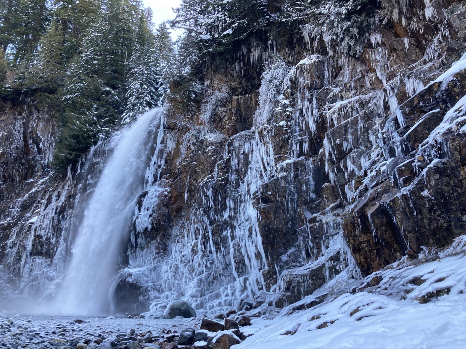
Franklin Falls is one of the most beautiful waterfalls in Washington and Franklin Falls in winter is even more spectacular! You can even catch a frozen Franklin Falls if you get there at the right time. In December 2024 a new Sno Park area was moved to the summer trailhead – parking is no longer allowed on the road and the parking area is at the summer trailhead (approximately 3 miles from I-90).
Starting from this location, to go to the base of the falls and back is just under 3 miles with about 500 feet of elevation gain and loss.
More on these two options for getting to Franklin Falls in winter along with the benefits and drawbacks of each route are described below. In addition to the waterfall, you’ll be in a winter wonderland of snow laden old growth evergreen trees and along a lovely creek.
The area at the base of Franklin Falls is prone to avalanches and can be extremely dangerous when snow is present. Make sure to check the avalanche forecast and make conservative decisions (more on this below).
Franklin Falls is the homeland of the Snoqualmie People.
- Franklin Falls Basic Info
- How to know if a winter hike to Franklin Falls is right for you
- What to bring to Franklin Falls in winter
- When is the best time during the winter to go
- How to get to the Franklin Falls trail in winter
- Trail Description – starting from Denny Creek
- Trail Description – starting from Alpental Road
- Where to stop after for food and drink
- Electric Vehicle charging
Parking Pass: A Washington Sno Park pass is required at the parking area. This is different than in summer when a forest service pass is required (confusing, I know!).
Dog Friendly: yes, on leash. Use extreme caution with dogs (and humans) near the waterfall as it can be very icy at the end of the trail.
Cell phone coverage: Good
Restrooms: Pit toilet
Accessibility and Mobility: the first part of the hike is wide and fairly smooth, although the going may be challenging in deep or new snow. The last part of the trail down to the waterfall is extremely steep, with steps in places. It can also be very treacherous and icy. You can see the waterfall above this point, so you can stay above. Do not venture down if you are not prepared for ice and/or if there is snow present in the avalanche chute.
Is Hiking to Franklin Falls in Winter right for me?
Franklin Falls in winter is a really beautiful hike through a gorgeous forest, along a creek to an incredible waterfall. This trail is also exclusively between the two directions of a very busy freeway, Interstate 90. It’s important to mention this because it’s often left out of descriptions! The river and waterfall drown out the noise most of the time.
The trail itself has a moderate grade. There are some steps on the trail part of the hike to Franklin Falls, and the last part of the trail is VERY slippery and icy in winter when ice covers the rock steps and rocky area at the base of the falls. You can see the waterfall well without going down on the treacherous rocks!
Another thing to note about Franklin Falls in winter is that it’s hard to know for sure exactly what the snow conditions will be like, how icy it will be and if Franklin Falls will be frozen or not. I highly recommend checking out the Washington Trail Association’s trip reports for the latest information on the conditions.
What to bring to hike to Franklin Falls in Winter
With our short days, unpredictable weather and the longer hike than the summer one, hiking to Franklin Falls in winter requires a little more preparation and gear.
Read more here about what I bring a day hike in winter (and summer) as well as what I wear. I also have an extensive post about getting started with snowshoeing, including what to wear and what kind of snowshoes to buy or where to rent or borrow them.
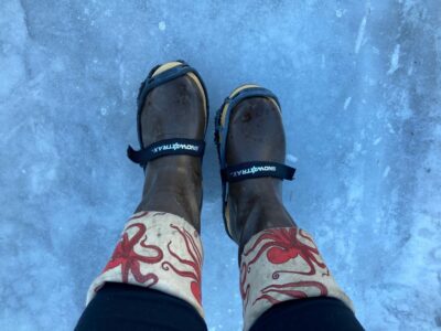
This hike might be good for snowshoeing, or it might be better to have microspikes. It really depends on the conditions that day and I would bring both in the car with me. I recommend bring microspikes with you no matter what (they’re inexpensive and in the what to wear post I talk about your options for what to buy!). Microspikes are like studded snow tires for your feet! You can fit them over any shoes or boots and they are amazing on ice. You might be able to do this whole trail with them instead of snowshoes, but if there is deep snow you’ll probably want both.
In my opinion microspikes are a necessity for Franklin Falls in winter, since the area directly around the falls and the last 100 feet of the trail are extremely icy much of the winter.
Make sure to bring plenty of food and water, extra layers and waterproof footwear.
When is a good time during the winter to hike to Franklin Falls?
I would recommend doing the hike to Franklin Falls in winter during a sunny, dry, cold period. This gives you the best chance of seeing Franklin Falls frozen. There is also an avalanche chute on the opposite side of the creek which is a danger in times of high avalanche danger. Check the avalanche forecast before heading out!
Generally speaking the coldest times with the most snow are in January and February, but this could also be a good option as early as December or as late as March.
Franklin Falls is very busy on weekends all year long.
How to Get to the Franklin Falls Trailhead in Winter
Franklin Falls in located in the Mt Baker-Snoqualmie National Forest, just west of Snoqualmie Pass. It is about an hour of travel time from Seattle. In winter it can sometimes take longer. There are two different ways to access Franklin Falls in winter. Both trail options are described below. As far as getting to the trailhead:
- Starting from Denny Creek (recommended): Take Exit 47 from I-90. Coming from Seattle, go left and cross the freeway. Coming from Ellensburg, go right at the bottom of the exit ramp. Immediately you’ll come to a T intersection, turn right. Go about three miles until the road ends at the new parking area for Franklin Falls
- Starting from Alpental Road (no longer recommended starting in 2025): I no longer recommend this as the Summit at Snoqualmie now charges a high fee with lots of restrictions to park at the ski area. Do not park illegally!
Trail Description – Starting at the Franklin Falls Sno Park
If you decide to park at Denny Creek and hike to Franklin Falls in winter, you’re looking at a 3 mile round trip hike with about 500 feet of elevation gain. Sometimes there will be deep snow from this point and other times you may be carrying snowshoes for the first bit. Microspikes will be very helpful here!
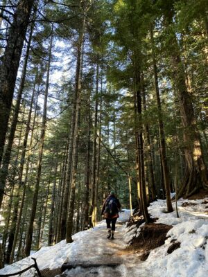
Start you hike in the forest below the parking area (good signage). You’ll be right next to the lovely South Fork of the Snoqualmie River which drowns out the freeway noise! You’ll continue to see gorgeous forest with old growth trees.
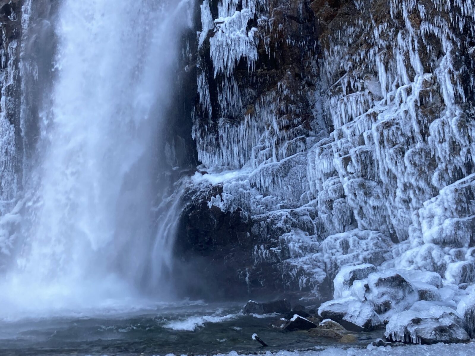
The trail is about a mile long and at the end there is an extremely slippery section! Having microspikes for your feet is really important here. I recommend carrying them in your pack even if you’re snowshoeing just in case. In addition to the slippery steep, rocky slope down, the rocks around the waterfall are also extremely icy so be careful and stay back if there’s any doubt about traction.
The waterfall never freezes completely but there may be different levels of icicles and interesting ice formations around it.
When you’re ready to return, return the way you came to you car. To go back a slightly different way that is along the Wagon Road Trail – this is a similar trail but provides something different and is about the same length. You will hear a bit more freeway noise on the Wagon Road Trail as it’s a bit further from the river.
Enjoy your picnic lunch here and get some amazing photos before heading back the way you came.
Food and Drink to Stop at After

If you parked at Snoqualmie Pass and hiked down to Franklin Falls from Alpental Road, then you can take in your post hike food without moving your car!
Try Commonwealth for pub food and Dru Bru Brewery next door. You can also grab a life changing hand dipped corn dog from Bob’s espresso directly across the street, next to the restrooms. In the same parking lot is Pie for the People, super tasty pizza in a convenience store (try it!). You can also grab pizza, pre made sandwiches, espresso and gifts in Red Mountain next to the WSDOT restrooms.
If you started from Denny Creek, you can either drive up to the pass to check out these same options, or you can head down to North Bend and check out Pioneer Coffee, Volition Brewing or the North Bend Bar and Grill.
Electric Vehicle Charging
There is fast charging at the Chevron station at Snoqualmie Pass along the road through the ski areas. It’s just down the road from the rest area and across the road from Summit West ski area.
It also works well for me to charge in each direction at the North Bend Outlets, which have more chargers available.


Related posts:


